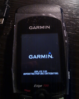
Being one to always pursue cheaper avenues for quality software, I did a quick search for free maps online for the Garmin unit, before being lead to a set of Open Source Open Street Maps for Garmin where there is a handy list of providers of maps for uploading to the Garmin Edge 705.
However, the link to the Australian maps that would be of most use to me at Open Street Map Australia were not present, showing empty ZIP files that weren't much use (Hopefully this is fixed some time soon). For these maps, I found a weekly extract of the Australian Open Street Maps at SteveZ's site that were very useful, and were actually linked to the OSM Australia website.
Once the maps were downloaded, the following steps were performed to get the map onto the Edge 705:
- Plug in the Garmin Edge 705 via USB to the PC
- Unzip the downloaded ZIP file
- The unit will come up as a Removable Storage Device in My Computer if you're on a PC (on mine it was G:)
- Copy the unzipped .IMG file to the G:\Garmin folder (or whatever drive it comes up as, so long as it is in the \Garmin folder)
- If you browse to the Garmin folder on the device you will notice that there is already a .IMG file called gmapbmap.img - this is the default highway map for your locality and is just a very high-level view that is pretty much useless for inner city cycling.
- Rename the gmapbmap.img file to something else, say gmapbmap.old
- Rename the .IMG file you have copied to the unit as gmapbmap.img
- Unplug the unit from the computer and power it up.
- You will now notice on startup that the default map is now an OpenStreetMap map (as per image)

There is also a program called Img2Gps that I found online that is intended as an interface to load the files to your unit, however, for all the stuffing around with this program it would appear all it does is copy the file to your unit, which, in my opinion, you are better copying the .IMG manually so you are confident it is placed in the correct place and named correctly.
Happy cycling!